Many Virginians are not aware that the Richmond Coal Basin was the home of the earliest large scale mining operations in the United States ‘s when shallow bituminous coal seams were found north and south of the James River in an area west of the Fall Line in what are today known as Henrico, Chesterfield, Powhatan and Goochland Counties.
The information in this article has come from several sources using an Internet search. Only the anecdotal information at the end of the article is original information. The rest has been sourced from others to whom credit has been cited in the article.
The first source is our favorite place to go, Wikipedia which has its own citations:
“The Richmond Coalfield was the first coalfield to be mined commercially in the United States of America.[1][2] The coalfield is located several miles west of the city of Richmond, Virginia. Its bituminous coal seams are a part of the Richmond Basin, dating to the Late Triassic.
Discovered around 1701, commercial production began around 1748. Production was centered in the village of Midlothian, Virginia, established to serve the various mines in the area. With the rise of numerous coalfields in Appalachia, in particular the Pocahontas Coalfield in Western Virginia, coupled with the difficulties in mining the field, the mines eventually closed by 1927. Overall production is estimated at more than 8,000,000 short tons (7,300,000 t).
As early as 1701, the coal deposits of the Richmond Coalfield were known to settlers, discovered by French Huguenots who settled in the Manakintown area.[1] Coal had previously been discovered in the 17th century in what is now Illinois.[1]
The first recorded coal production from the Richmond coalfield, and what would become the United States, dates to 1748. 50 short tons (45 t) were recorded mined that year.
By the end of the 18th century, coal mined in the field was being shipped to Philadelphia, New York City, and Boston, where it was sold well into the mid-19th century.[1][4]
Manchester Turnpike Chesterfield Gravity railway Richmond and Danville Railway, from Richmond, Virginia, southwest toward Danville, Virginia.
Major companies involved included Black Heath, Midlothian, Clover Hill, etc.”
(source: https://en.wikipedia.org/)
The Midlothian mines and early railways in Chesterfield County have been well documented by many sources including https://www.midlomines.org and https://www.energy.virginia.gov. There are artifacts of those operations that can be visited today.
Less publicity has been given to the mining operations north of the James River in western Henrico and eastern Goochland Counties where there several clusters of mining operations with railroad services. While there are markers in Deep Run Park commemorating the rail line that ran through Deep Run Park to the RF&P connection to the east and the Coal Pit School in western Henrico, there are is not much left to indicate that mining ever occurred in the area. This can be attributed to the westward growth of the Richmond metropolitan area in the 1960’s and 1970’s when mine shafts were filled in and the landscape was graded to make way for the multitude of neighborhoods that would grow along Lauderdale Road, Gayton Road, Springfield Road and in-between. Today there is little to indicate there was ever a coal pit or shaft. We do know that there was a mining village of Gayton developed around the coal mine in the area of the western part of the county and there are remnants of the rail bed in Deep Run Park. The village has disappeared but the name Gayton Road comes from the Gayton Coal mines originally owned by DuVal Coal interests.
Fortunately, there are historical accounts of Henrico’s mine disasters, a state sponsored survey of abandoned mines, a Henrico County sponsored video, a collection of coal company documents at the State Library of Virginia, some photographs and some recollections of those who had witnessed the mining activity in the area.
Internet research cites a 1938 publication The Richmond coal basin: a compilation in three parts by Ira F Davis but a copy of the location of this document could not be found by the author.
According to the ArchiveGrid website, the following information is available at the State Library of Virginia:
“Richmond coal basin project file, 1811-1953. This is a collection of information about the Richmond, Virginia, coal fields by the Swartwout family who owned local coal property. Included are general reports on the Richmond Coal fields, Gayton coal mines, property owned by Old Dominion Development Company, Richmond Coal Mining and Manufacturing Company, Manakin Iron Works, Carbon Hill mining tract, Railey-Heth Coal pits in Chesterfield County, and Coalbrook operations. Several of the reports include sketches of the coal basin strata. Reports, newspaper articles, and letters are by Decatur Axtell, B.F. Bush, S. Harris Daddow, E.V. d’Invilliers, Conway Moncure, William Barton Rogers, Edward M. Tierney, P.L. Torrence, H.A. Treadwell, F.R. Wadleigh, John I. Werth, T.M. Wortham, and John P. Yeatman Richmond coal basin project file, 1811-1953, Accession 34213, Personal papers collection, Virginia State Library and Archives, Richmond, Virginia” (https://researchworks.oclc.org)
Available Maps of the Richmond Coal Basis
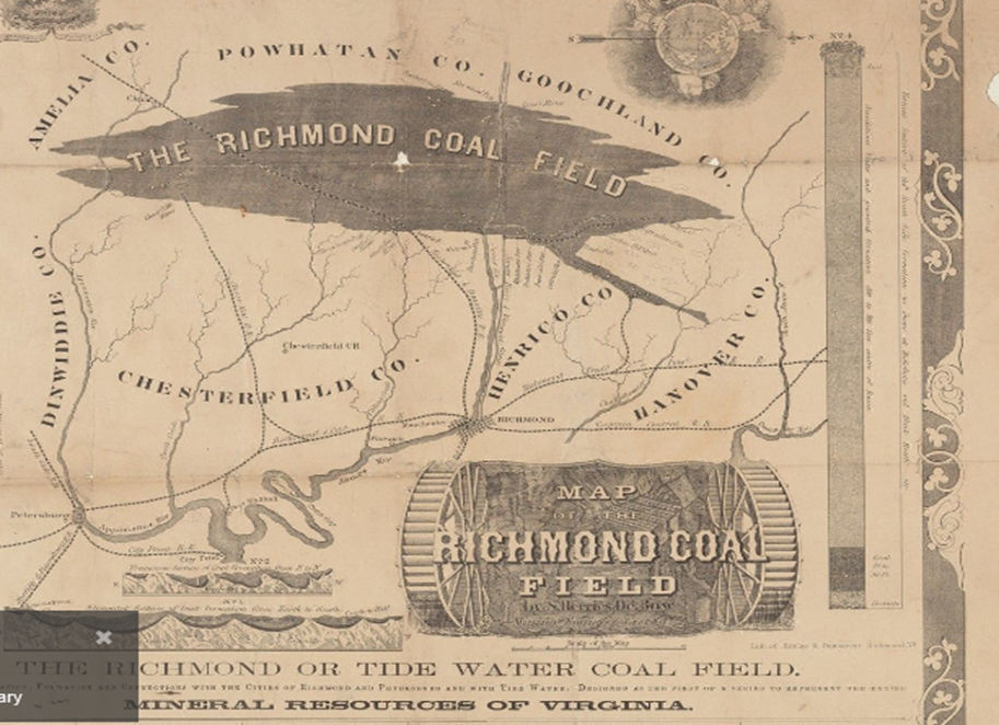
In 1858, a map of the Richmond coal field was produced by S. Herries De Bow, Mining Engineer, Geol, &c.; lith. of Ritchie & Dunnavant, Richmond, Va. showing the railroad lines in the area including those supporting the mines and the active mines in the area of the west of the fall line. The map is currently part of the Yale University Library collection that was found on the Internet (https://collections.library.yale.edu).
Of interest to this article was the railway that began on the east side of Tuckahoe Creek from the Magruders Pit and journeyed in a southwestern path to include the Carbon Hill, Truetts, Cottrells, and Tuckahoe coal pits until terminating at the James River and Kanawha Canal. There was also another railway that connected the RF&P line running to the mines at Deep Run and the area along Springfield Road north of present-day Broad Street Road. The map has been reproduced below.
A copy of the map follows:
In the process of researching for materials for this article, the researcher was fortunate to have found a table with following list of mines in western Henrico published by Henrico County (https://henrico.us)
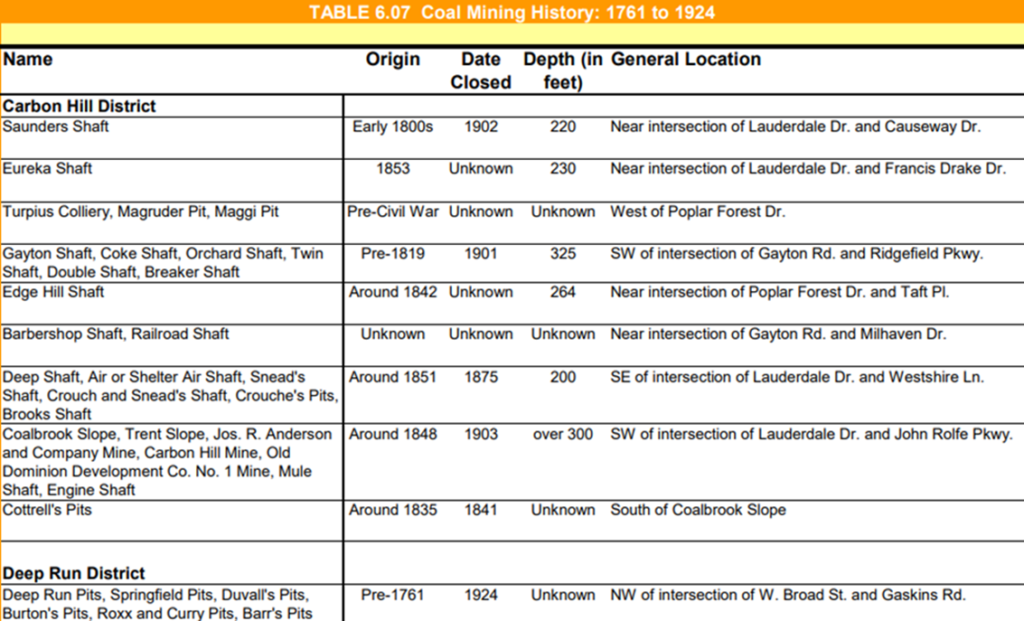
Source: “Mining History of the Richmond Coalfield of Virginia.” Commonwealth of Virginia Department of Mines, Minerals and Energy Division of
Mineral Resources. Charlottesville, VA 1988
Henrico Mining Disasters reported:
The mining operations had their perils has was reported at the time in national newspapers and further documented by the United States Mine Rescue Association (https://usminedisasters.miningquiz.com).
Old Dominion Development Company
Carbon Hill Mine Explosion
Gayton, Henrico County, Virginia
July 16, 1912
No. Killed – 8
See also:
Carbon Hill No. 7 Mine Explosion, Dec. 9, 1899
Carbon Hill No. 1 Mine Explosion, January 21, 1911
Carbon Hill Explosives Detonation, January 16, 1912
________________________________________
(From Bureau of Mines Report, by H. I. Smith)
The shot firer went to the face of 2d left gangway and found an accumulation of gas, then went back and told some men that he was going to take a chance in firing shots in that face with fuse instead of using a battery. He lit his pipe and went back to the face and charged the holes. He lit one fuse with his pipe but failing to light the second fuse from the first one, he struck a match, which ignited the gas, resulting in an explosion which killed eight men arid injured another.
The explosion was confined to six rooms along the gangway. Two rescue parties put/up a canvas brattice line and recovered the bodies. Some of the rescue men were overcome but revived by use of compressed air. The mine was gassy, ventilation was weak, and open lights were used on the slope and main gangway; safety lamps were supposed to be used in all other parts of the mine. The coal dust present did not propagate the explosion. From January 1909 to June 1912, 6 explosions in this mine resulted in the death of 28 men and injury to 32 others.
Carbon Hill Coal Company
Carbon Hill No. 1 Mine Explosion
Carbon Hill, Henrico County, Virginia
January 21, 1911
No. Killed – 7
News articles from the period (6.4 Mb)
See also:
Carbon Hill No. 7 Mine Explosion, Dec. 9, 1899
Carbon Hill Explosives Detonation, January 16, 1912
Carbon Hill Mine Explosion, July 16, 1912
________________________________________
Initial statement following the explosion: Five men killed and 4 fatally injured and 7 others injured as a result of the explosion of dynamite or gas in the Gayton mine, about 15 miles west of Richmond, early today. All of the dead are Poles who came to Virginia from Pennsylvania. The 6 men who were injured are still in the mine about 1,200 to 2,000 feet from the entrance. The exact cause of the explosion is not certain.
Photographs of the Mine
The number of photographs of the mining operations appears to be limited. Research on the internet has only turned but two photos. The first photo is labeled as the Gayton coal mine without specific reference to its location in the west end of Henrico.
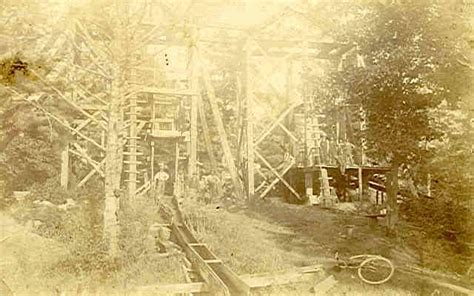
This is another better photo of two men in front of a mining tower around 1912 from the Valentine that is only available by linking to the following website.
The author cannot verify where this structure was located given the number of possible sites in Western Henrico.
Video Documentation of Mining Operations
For those interested, Henrico County produced a video a few years ago that focused on the old mining site off Lauderdale behind Lakewood Manor retirement community: https://www.youtube.com/watch?v=tU7E2WpfVrA. The video runs for about twenty-minute video.
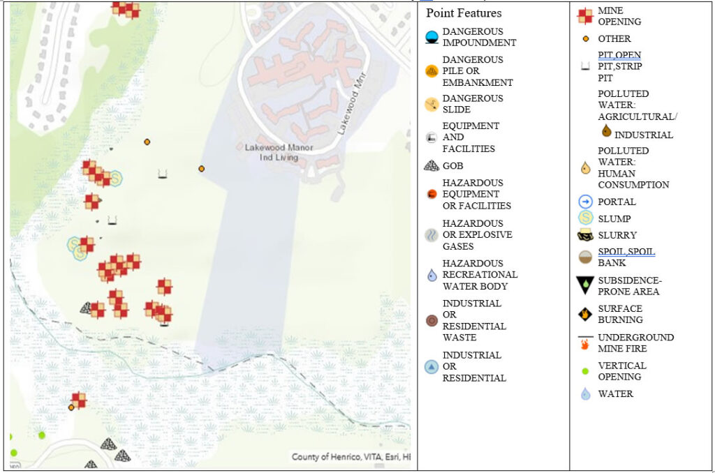
If you want to know how close you live to a coal mine shaft or pit (hopefully filled in and settled, or not), go to
https://vadmme.maps.arcgis.com
Here is a screenshot from the interactive map of the survey done in 2011 -2012 by the VA Bureau of Mines. This screenshot is west of the fall line with the Springfield mines to the upper middle and Midlothian mines to the bottom. The Map allows a user to drill down to the street level.
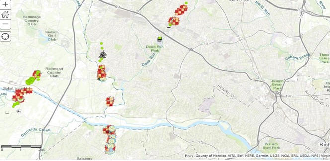
The area around Lakewood Manor off of Lauderdale at John Rolfe Parkway as an example of a street view.
Anecdotal Information on the Coal Mines
The following information came from a recent interview the author had with Jim Lavender, the founding pastor of Discovery United Church that is located at the current intersection of Gayton Road and Lauderdale Drive in the far west end of Henrico County. Discovery UMC is located about two miles up the road from intersection of Lauderdale and John Rolfe Parkway and across the street from Pine Run neighborhoods where pre-Civil War mines were operated.
The Methodist Church purchased the Discovery property in the late 1970’s with the intention of starting a new church to service the burgeoning neighborhoods growing from Pump Road out to the wilds of Lauderdale Road. Jim told the author that when the Methodist Church bought this property, he was involved in the inspection of the property for planning where to place the initial facility (a tent). There as a ten-foot-wide mine shaft on the northeastern corner of the lot (which is marked on the VA Dept of Mining survey of abandoned mine on the second lot on California Drive) and another shaft on the south side facing Lauderdale (which was not marked on the survey) had to be filled in before the land could be used. There was also a large coal slag pile (that the author remembers) on the eastern side of the property behind the church. The coal slag pile was removed when the rear parking lot was installed, This site is now going to be site of new townhouses. Jim said they had to bury a mechanical coal crusher in the front yard at the intersection of Gayton and Lauderdale because it was too large and expensive to cut up and remove in developing the property. On this knoll, there was a small metal piece from the coal crusher that was sticking up which ruined a few riding mowers of unaware groundskeeper. Jim remembers seeing rail tracks on the site that were covered up along with some scrap from rail equipment that one rail enthusiast took home.
Other commentators have observed that temporary rail beds and tracks were laid down wherever the coal pits and shafts were operating and relocated as the pits were exhausted and abandoned in favor of more productive sites.
Then the author moved into his neighborhood off Pemberton Road in 1984, the plat for the property showed the railroad line running through what would become Deep Run Park. That line has been abandoned decades before as part of the line that ran over the RF&P interchange.
Other commentators in a NextDoor conversation string have added information passed on to them from prior generations about the filling of the coal pits, foundation cracks on houses built near coal pits and mines, trekking in the woods before any development of the area occurred, and potential location of the village and its main structures. A lot has been lost to history but is still fascinating to think about how these people lived and worked so many years ago in an occupation that most can only relate to the remote valleys and mountainsides of Appalachia.
As further information is available from readers of this article and a visit to the State Library of Virginia, we will append this article.
If you have anything to contribute, please send us your information at VTCA@Vatraincollectors.com.
Leave a Comment